Hiking in the Julian Alps (incl. intro to the Alpine hut system)
I try to do at least one longer (>200km) hike a year, but this year I couldn't do it. I hurt my knee, and my hiking buddy had work commitments, so we decided to do something shorter and closer to home than usual. It was a perfect opportunity to do that hike in Slovenia that we had been thinking about for a while. It was my first long-distance hike in the Alps, and my first experience of the Alpine hut system. If you're planning to go, here are some things that I wish I knew before setting out.
Trail #
Location #
We hiked a subsection of the Slovenian Mountain Hiking Trail (Slovenska planinska pot), which some claim to be the oldest hiking trail in Europe. We did the portion that traverses Slovenia's only national park - the Triglav National Park. We started in Mojstrana, and finished in Črna Prst. The journey was around 125km long, and took us 7 days, including a rest day. We cut out two large peaks (Prisojnik and Jalovec). If you want to climb those, you need to budget an extra day. The trail is very well documented elsewhere on the Internet, so I won't be posting detailed maps.
Getting there #
... is very easy. A bus from Ljubljana to Bohinjska Bistrica (southern starting point) or Mojstrana (northern starting point) costs 1.90 EUR and departs every hour from the main bus station. We travelled to Slovenia by a long-distance bus, which conveniently stopped in Bled, a picturesque town at the edge of the national park.
When to go #
We went in early September. The weather was beautiful for the entire week, and the trails largely empty (except for the more popular ones during weekend). Around the third week of September, many huts close, and some buses do not run, so you may need to plan accordingly if you want to go later.
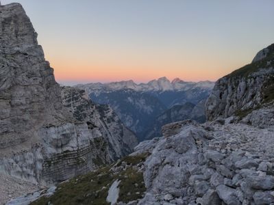
Qualitative description #
The path is very comprehensive. It meanders and winds back on itself a lot in order to cover all the major landmarks in the national park. Sometimes, it's a bit frustrating to hike for three days and end up 500m away from where you started. However, every single peak and pass on the way is worth visiting; going in a straight line would get you out of the national park in no time, and you'd miss a lot. Going the long way also means that you can avoid towns; the trail stays high throughout the whole length - you only descend into a valley once.
The route (and the national park) can be divided into two main sections. The upper one, from Mojstrana to Trenta, stays around 2000m, and is mountainous and dry. The lower one, at around 1500m, oscillates between small coniferous shrubs and a lush mixed forest. Both parts are excellent in their own ways. The upper one has many fun climbs, with a lot of infrastructure (cables, spikes), which makes almost all major peaks accessible without intense mountaineering gear. The lower one is very green. You will meet many ibex, alpine choughs and eagles in the upper sections, and (if you're lucky) marmots and vipers in the lower ones.


Do not underestimate the complexity and difficulty of the higher sections! This is not your typical through-hiking trail. Unless you're extremely fit, you will not average 30km per day. The time required to traverse a section is independent of its length. Sometimes you can do a 10km section in 2.5 hours, but, if it features a hairy vertical climb, it may take a day. Most people we met on the way were wearing helmets, many had harnesses. Some scoffed at our trail runners and shorts. There are many exposed sections which could be pretty scary in bad weather. Climbing is very rewarding, and there is a lot of hardware to help you when needed, but in many places a stupid mistake could get you badly hurt.
Having said that, we have met many children and elderly people on the route. It's very accessible in the right conditions, you just need to be careful, and realistic in your planning.

Navigation #
The entirety of the trail is on a well maintained, well-marked path. We carried a Sidarta 1:50,000 Julijske Alpe map that we bought at the local tourist infopoint. It was useful for planning, not for navigation. As far as we could tell, more detailed paper maps are not available. We used a smartphone here and there when we were unsure, but most of the navigation is very straightforward, you're simply following the blazes.
Sleeping #

Walking from hut to hut #
You have to stay in huts, which Slovenians call Koča. Camping is not allowed, and the authorities do enforce the rules. There are many huts, but they are not evenly spaced along the route. This means that on some days you have to hike for 10 hours, and sometimes you must stop after five. How far you can walk on a given day is largely determined by the time required to reach the nearest hut. Those times were listed on the back of our map, they are also written on the sides of each hut. For some reason, they don't seem to be available on the Internet. Times on our map were pretty accurate; we usually took 70-80% of the listed time, but we had really good weather. Carry a map for day-to-day planning!
Hut etiquette #
There are many articles online on the rules and etiquette of Alpine huts. I recommend the original one from the Alpine Association of Slovenia. Some points which were not clear to us before we set out:
- If you're a member of an alpine association, hut prices range from 26EUR for the more expensive huts up in the mountains to 15EUR for cheaper ones in valleys. Prices are standard, set by regulation. The more people in your room, the cheaper it is. The membership gives you 25-50% off the room price, depending on room type, and pays back for itself after a few nights. It also provides rescue insurance. We're members of the Austrian Alpenverein.
- To sleep in huts, you need to have your own bedding (or pay an extra ~5EUR per night). They do not allow sleeping bags - they have issues with bed bugs moving from one hut to another. Most people just use a sleeping bag liner (which in German is called a Hüttenschlafsack - literally a hut sleeping bag)
- In busier times, you need to make a reservation to guarantee a place in a hut. We usually did not, because we were unsure where we would end up each night. This was only a problem during the weekend in the most popular area of the park (around Triglav). During the week, we were often the only people in a hut. However, we hiked in September; during the summer, there may be more demand. I'm still not sure what they do if there are not enough beds. Most people seemed to find it obvious that you would book a place weeks in advance, but we did not meet any other through-hikers. There is phone reception throughout most of the range, so we tried to call ahead once we were sure where we would end up on a given night.
- Huts also offer food (or half-board accommodation), at fairly affordable prices (~10EUR/dish). Not much of it is vegan. We tried eating at a hut once, and we were oferred barley soup and a strudel, which was obviously not enough calories after a day of hiking.
Food #
We cooked our own food every night. This meant that we carried food for 7 days. There is a shop in the middle of the way (in Trenta), but it's not well equipped. The museum next door may, however, accept a food parcel.
A major problem along the trail is the availability of water, especially in the upper bits. For most of the way, the only sources of water are huts. Tap water in huts is not drinkable, but they will sell you (very expensive) bottled water if required. We brought a water filter and drank filtered hut water. There are sections (e.g. Koča na Doliču -> Pogačnikov dom na Kriških Podih), where you need to carry enough water for 6h of hiking in the scorching sun. We brought 2l of bottles per person, but upped it to 3l per person on day three.
Gear #
We did not meet any other through-hikers on the trail. Most people were day-hikers in mountaineering boots, long trousers, with helmets and harnesses. We were very comfortable in our regular hiking outfits - shorts and trail runners. None of the sections that we did required clipping into a via ferrata. We did not carry a tent - the handful of legal campsites on the way did not justify the weight.
Summary (incl. obligatory environmentalist rant) #
The Triglav National Park is stunning, and absolutely worth a visit. Just like most places where I've hiked, it's (sadly) worth going as soon as possible; the area is being developed for tourists' convenience, and destroyed in the process. On the way, we saw half a hillside being levelled to make way for a luxury ski resort. There is often a brass band on top of Triglav. Every day, you (and all the animals who live there) are disturbed by helicopters full of people who want to enjoy the view without making any effort. The huts are becoming fancier and larger, but many still don't have waste treatment facilities. Go, but (unlike many) do your best to leave no trace.