A (supplemental) guide to the Cordillera Blanca Traverse
In September 2022, we did the Cordillera Blanca Traverse (CBT), a through-hike in the Peruvian Andes. The CBT is a scenic route through some of the prettiest mountains on the planet. It starts in the north side of the range, in a tiny village of Hualcallan, and zigzags all the way through, ending at the Pastorouri glacier.
It was first proposed by Cam Hogan in 2014 on his blog The Hiking Life. Since then, a few other people have attempted it, but information on the Internet is still scarce, and there have been changes on the ground since the original post was published. In this guide, we'll to give you some updated information on the route, and describe how we tackled it. Of particular interest may be our data on some of the scarier, undocumented high passes in the middle of the route. We will not repeat things that you can find on Cam's blog or in guidebooks, please treat this post as a supplement to those.
This post was written in collaboration with my hiking buddy, hence the liberal usage of 'we'.
Stats #
The route is around 350km long, and involves about 18km of total ascent. It can be completed in 16-22 days. We took 18, but on two of those we only walked 4km due to altitude sickness and food poisoning. Including rest days, you should budget about three weeks, plus acclimatisation.
Navigation #
To navigate, we used three main sources of data:
- Cam's Quick and Dirty Guide has GPX points from his 2014 attempt, many of them with useful tips.
- Alpenverein topographic maps 0/3a and 0/3b cover the entire range. They're, sadly, only available in 1:100000 scale, and were made in 2006, so some information is out of date.
- The guidebook Peru's Cordilleras Blanca & Huayhuash - The Hiking & Biking Guide covers a large portion of the trail. They also provide GPX points. It's well-written, and useful for getting around, finding information on public transport, shops, restaurants etc.
We loaded the GPX points into a navigation app, and used our phones most of the time, with paper maps and a compass as backup.
On the way, we created a fourth resource - we recorded our tracks on the entire trail.
Our GPS tracks and photos
Individual days: 1 2 3 4 5 6 7 8 9 10 11 12 13 14 15 16 17 18
PLEASE DO NOT THINK YOU CAN JUST FOLLOW THOSE EXACTLY. There were times where we did not follow the best route. We tried to mark those bits, but we cannot guarantee accuracy. If you need a precise trace to follow, you should not be doing this hike. The waypoints are more accurate, but still not perfect. Some of them have photos though!
Stage 1 #
Stage 1 is almost entirely on trail. For the first few days, it follows the well-trodden Alpamayo-Santa Cruz trek. This trail is covered in the guidebook, and the paths on the map, and in most navigation apps, are accurate. After departing from the Santa Cruz trek around the village of Colcabamba, CBT follows the Ulta-Yanama trail, which is also featured in the guidebook.

The only exceptions/difficulties are:
- The forest at
(8.82601, -77.57188), near Laguna Sactaycocha. Cam claims there's a trail there, and so does the map, but the forest is terribly overgrown, which makes the path impossible to follow. We went right by the lake, and then took too long to rejoin the main route, which necessitated some steep climbing afterwards. Make sure you join the main path as soon as you leave the forresty bit, and then follow it precisely. The valley afterwards is cut by multiple tall gorges, and ends in a cliff down which there is only one, narrow, difficult to find path. - As you're about to reach the village of Jancapampa, at
(-8.85127, -77.54876), contrary to what Cam says, there is no bridge. Follow the edge of the valley until you're able to cross and reach the road. It's very boggy, so don't try crossing straight on if you want to keep your feet dry. Right after (at(-8.85571, -77.53100)), just before the village, there's a new 4x4 track leading up to it. The trail in the app is now completely wrong, and so is Cam's point at(-8.85514, -77.52797). - There is now a new 4x4 road at
(-8.92321, -77.50935), leading up to Laguna Wicrococha. You can follow it to get to the lake. This makes the old path on the map/app obsolete. - We did not find a good path to climb up to the tunnel at Punta Olimpica. Cam's original trail starts on a nice path, which quickly becomes overgrown, and then disappears, at which point you scramble up to the road, and then walk for 3km on asphalt. There is apparently another path, which starts on the 4th bend in the road, and then ends right next to the tunnel. It may be worth inquiring about. To descend from the tunnel, we hitched a ride, as we did not feel like walking for 18km on a busy road.
Stage 2 #
Stage 2 is the most fun of all, but it also has a number of poorly documented passes. For some of those, we found out the optimal route. For some not.

Portachuelo de Honda #
There are two ways to cross this pass. We chose the western side, because it saves a few kilometers of walking down the road. This trail is on the Alpenverein map, but it is not featured on any of the navigation apps that we checked. The path here can be quite difficult to find, but by following Cam's waypoints and sticking to the overgrown old, wide road, we managed to get a very smooth, easy going for the entirety of ascent and descent. Feel free to be inspired by our GPX trail here.
Paso Urus/Akilpo #
This trail is in the guidebook, but it's not well described. The ascent is very easy, just follow the cairns. For the descent section, cairns are misleading and hard to find. The guidebook simply tells you to scramble down carefully, which is not helpful. Especially the final 200m is on a very steep slope. It seems like one of the popular navigation apps has just added a trail for this section, which may be worth exploring.
Ishinca pass #
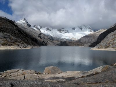
Again, there are two ways to do this one. We chose the Ishinca/Ranrapalca col. pass, which involves walking across a glacier. Definitely try asking people in the shelter underneath if it's safe to cross, but we got conflicting advice there. It seems like the shelter was handed over to a new team, and they don't have much experience in the area. Walking up the glacier follows a well-established mountaineering path. It's important to find a good entry point onto the glacier. The point marked on Cam's GPX - (-9.39592, -77.41831) - is no longer viable. Probably due to the glacier melting, ground there is no longer covered in snow, and the section immediately behind it is icy. We scrambled further south, and entered the glacier in a nice, snowy area. It's incredibly beautiful. We headed straight across the glacier, shooting for the obvious notch on the other side, and avoiding crevasses and steep slopes. We crossed using just microspikes, which is not the correct equipment for this kind of traverse. We were fine, but your mileage may vary. Also, Cam's location of the pass is incorrect, it's actually slightly further north, at (-9.40109, -77.41177). The descent is not unpleasant, but it is long. We followed cairns which lead you to L. Perolcocha on a roundabout trip to avoid a steep cliff. It seems like for this pass there is now also a trail on a certain popular navigation app.
Paso Huapi #
Cam calls this one Choco pass, but it's universally known as Paso Huapi. It is in the guidebook, and all the navigation apps have good trails for crossing it.
Stage 3 #
Stage 3 is the most challenging of all, because it involves two passes that are completely undocumented, and fairly technical. One of them is, arguably, not safe to cross without mountaineering equipment in certain years.

Shallap pass / Paso Huamashpunta #
We're pretty sure that we took the wrong way down this pass, so we can't really help with crossing it. Two campesinos (local farmers) that we met under the pass told us that there's a good path, if you can find it, and that this pass is pretty easy. We found a good path at (-9.49540, -77.35956), after the buildings next to the lake. The path appears and disappears constantly, but it's quite easy to get to Cam's GPX points on the ascent. The descent, however, is pretty hairy. There's a lot of scree and sand; you're basically sliding down the slope, hoping that you'll manage to stay in control. There may be a better way. Some agencies in Huaraz offer a tour across Paso Huamashpunta, it may be worth asking them which way they go.
Also, OpenStreetMap-based navigation apps (i.e. most of them) say that there's a refugio (shelter) next to Laguna Rajucolta, after the pass. There isn't.
Cashan Pass #
The same campesinos who told us that Paso Huamashpunta was easy, said that we were muy bravo if we intended to cross the Cashan Pass without mountaineering equipment. In 2021, they said, they used a 20m rappel to do it. They may have been colouring things a little.
Ascent to and descent from the pass are smooth and pleasant. You start by following the Yahuaraju trail, and then at some point shoot southeast towards the pass. It's a nice, meandering path through grassy fields. It's easy to follow Cam's GPX points.
The last 200m of the ascent are pretty tough. You're scrambling up a field of loose scree. One of Cam's GPX points says:
Angle here to base of cliffs, ‘easier’ walking
Do this as soon as you can. Walking below the cliff is much more stable. At points it makes sense to climb over bits of rock, rather than follow the edge.
Once you get to the top, you reach possibly the most dangerous bit of the whole traverse. Even in September, the first 20m or so of descent was covered in snow. The only option to get down was a 1m-wide chute at the base of a cliff.

We descended in microspikes, kicking steps in with trekking poles. The scariest bit was at the top, where you need to boulder in order to enter the chute. Many rocks were weathered loose, we needed to check every handhold and foothold.
Once you're down the chute, the path is clear and easy to follow all the way down to Q. Rurec. If you need to rest in a shepherd's hut on your way down, it's actual location is (-9.57515, -77.34324), not (-9.57880, -77.34362).
We think that we followed a good route through this pass, but the crossing itself did not feel safe. A few weeks prior, it had likely been impossible without an ice-axe, crampons, and rope. The alternative route (down Q. Rajucolta and then across) may be longer and less scenic, but we'd consider it, especially if hiking earlier in the season. One tour agency in Huaraz (Tourismo Galaxia in Parque Guinebra) offers the Cashan crossing on their website, so it may be worth asking them what the conditions are before leaving for stage 3.
Way to L. Querococha #
The way from Q. Rurec to L. Querococha is straightforward, along pleasant, rolling hills. Cam recommends walking along the lakeshore, and indeed, there is a very nice path there. We decided to follow the high path above the lake before desceding to the shore around (-9.71229, -77.32749), as this way has better views. So did a local that we met along the way.
Stage 4 #
There isn't much to add to the information already available for stage 4. Around half of it is off-trail, but along very easy terrain. Cam's GPX points are more than enough here. A few minor points:
.
Q. Raria #
There are two paths in this valley, one on the north side, one on the south. The southern path is not on the Alpenverein map, but it's much drier. To reach it, we recommend taking the obvious path down from L. Acococha, passing through (-9.87051, -77.28287), which will take you almost to the road at the bottom of the valley. Then join the better path, which is marked on most apps, around (-9.87232, -77.27634 ) (we joined much later, which required an awkward stream crossing). This way through Q. Raria is also described in the guidebook.
Landslide pass #
There are two ways to finish the CBT. One involves going through the Gajap pass on the eastern side of Q. Puchua, one through a notch at it's south end, which Cam called the Landslide pass. This area had a major landslide back in 2014, and the locals advised Cam not to walk cross it then. In 2017, Ryan "Dirtmonger" Sylva was given the green light. None of the people we asked knew about this pass. The locals seem to regularly use the Gajap pass, which takes you on a pleasant walk to the beautiful L. Japrucocha, which is a great lunch and swim spot. You do walk on a 4x4 road for an extra 8km this way, but it's a quiet one with really good views.
Other tips #
Here are some random things that we wish we knew before starting.
Air in the mountains is extremely dry #
Definitely bring lip balm, consider skin lotion if you've got dry skin or like hiking in shorts.
Sun at this altitude is strong #
Either wear clothing that will cover you up (like me), or carry copious amounts of suncream (like my hiking buddy).
Vegan hiking in Peru #
Food on trail #
We hiked fully vegan. Almost every meal was cooked. This was time consuming, but forced us to take decent breaks and meant we could save weight with more dehydrated ingredients.
We aimed for ~3,300 calories per person per day, splitting then pretty evenly between breakfast, lunch, dinner and snacks.

Breakfast #
- porridge with powdered coconut milk, cinnamon, chocolate and nuts
Lunches #
Long life bread (e.g. tortillas) with
- vegan cheese (this didn't last long in the heat, so needed to be eaten close to resupply points)
- avocado (these also tragically go off)
- rehydrated beans
- rehydrated hummus
- peanut butter
Dinners #
- rehydrated beans with rice, fritos and vegan cheese (thanks to Andy Skurka for the idea)
- rehydrated lentils with freeze dried spinach and rice
- Thai curry paste with powdered coconut milk, ginger, cashews, vegetables and rice
- instant noodles with peanut butter, powdered coconut milk, peanuts, ginger and soy sauce
- pasta with dried pesto, dried tomato, freeze dried spinach and vegan cheese
All of the above involved a lot of garlic, spices, and oil.
Snacks #
- nuts (so many nuts)
- bars (Peru has a great selection of cheap, calorie dense bars)
- chocolate (surprisingly hard to find in a country famous for it)
- sweets
- biscuits
I travelled to Peru via the USA, so we could stock up on vegan cheese, nooch, fast-cook rice, and fancy dehydrated things like spiced beans (excellent, would highly recommend), lentils (fine) and hummus (revolting) from the Outdoor Herbivore.
We carried a Sawyer Squeeze water filter. It was very necessary given the amount of water we were drinking (5l+ each per day) and the abundance of horses and cows roaming the valleys, making the pristine glacier water somewhat less pristine.
Food drops #
We did three food drops prior to starting the hike. This meant we carried a maximum of 5 days of food, plus a back up day, at a time. The back up day supply was essential: we used it on both stages 2 and 3 due to illness slowing us down (see above). Don't miss it! Our first food drop was in Yanama, where we took a rest night at the cheap and friendly Hostal Micky, the second in Huaraz where we took a full rest day, and the third in Chavin, where we languished with food poisoning.
For us, food drops make a lot of sense: they save resupplying during the hike and the associated time and worry, and let you optimise your weight/nutrition/calorie balance. This is especially true as, being vegan, it's unlikely we would be able to find five days worth of lightweight, long life calories in Peruvian villages. However they did mean we spent a lot of our acclimatisation week taking collectivos around the cordillera. A word of caution: it turns out the collectivo to Yanama sometimes arrives after the collectivo back leaves, necessitating an overnight stay. Happily we managed to combine the return journey with a climb of Laguna 69. Upon reflection, it would have been equally possible to do the third food drop in Huaraz rather than Chavin - the point you leave the trail is equidistant between the two. Which you choose depends on whether you consider a rest night in Chavin, which is charming but not markedly more so than other villages, worth the seven hour round trip it takes to do the food drop beforehand.
Veganism in civilization #
Peruvian cuisine is meat-based to an extreme level. Ubiquitous vegan food is largely limited to:
- chips (papas fritas)
- crisps (also called papas fritas)
- avocado rolls (sold on the street in the mornings)
- fried bread (sold on the street in the afternoon)
- vegetable soup
- many delicious fruits
- equally delicious juice bars
In terms of eating out in Huaraz, we found an excellent Indian restaurant (Paulinos), a pizza place with tasty marinara (La Comedia, vastly better than all the other pizza places) and discovered that chifa rice can be vegan if you ask for it. Although sometimes they just pick the chicken and egg out of chifa rice they've already made, which we're pretty sure was the source of our food poisoning episode, so be cautious. The gringo haunts, Cafe Andino and Cafe California, do great vegan food and have non-dairy milk. Unsurprisingly, they have European prices and you won't meet many locals there.
Climate change #
The white (blanco) tropical glaciers that give the range its name are disappearing at a ridiculous rate of up to 200m/year in some places. The valleys are being covered in new roads and construction. The mining operations in Q. Honda and Q. Juitush are expanding. We felt very privileged to be able to do this hike while the Cordillera Blanca were still relatively untouched. For the vast majority of the 2.5 weeks it took us to do it, we were the only people in sight. If this is your thing, go sooner rather than later.
- Previous: A hydrogen strategy that makes sense
- Next: Are carbon offsets useful?